Move beyond task-specific models
Maritime systems often need trajectory prediction, anomaly detection, routing, ETA estimation, and market analytics under shared context. A single backbone can reduce fragmentation.
A Vision Report for Unified Maritime Intelligence across Vessel Mobility, Environmental Context, Regulations, Port Networks, and Market Dynamics
University of the Aegean · Archimedes/Athena RC · Athena RC · Hellenic Mediterranean University
Existing modeling approaches for global maritime traffic are fragmented across narrowly scoped tasks and fail to provide unified representations spanning strategic, tactical, and operational planning layers while accounting for safety and efficiency.
This vision paper outlines the foundations of a general-purpose multimodal model for the maritime domain, enabling predictive, analytical, and optimization-driven intelligence. By leveraging diverse maritime data, the model captures recurring mobility patterns and connects operational signals with sector-level dynamics. We contextualize such models within maritime analytics by identifying the planning layers they must represent.
Additionally, we examine challenges and opportunities in multimodal integration and representation learning, including key resources and design considerations, and relate these to downstream tasks. The paper proposes a blueprint aligned with domain requirements and provides an extended bibliography.
Maritime systems often need trajectory prediction, anomaly detection, routing, ETA estimation, and market analytics under shared context. A single backbone can reduce fragmentation.
AIS trajectories must be aligned with vessel particulars, ports, nautical maps, weather, hydrography, regulations, financial signals, and news-derived context.
After pretraining, the FM can be adapted through task heads, full fine-tuning, or parameter-efficient methods such as LoRA, adapters, and prefix tuning.
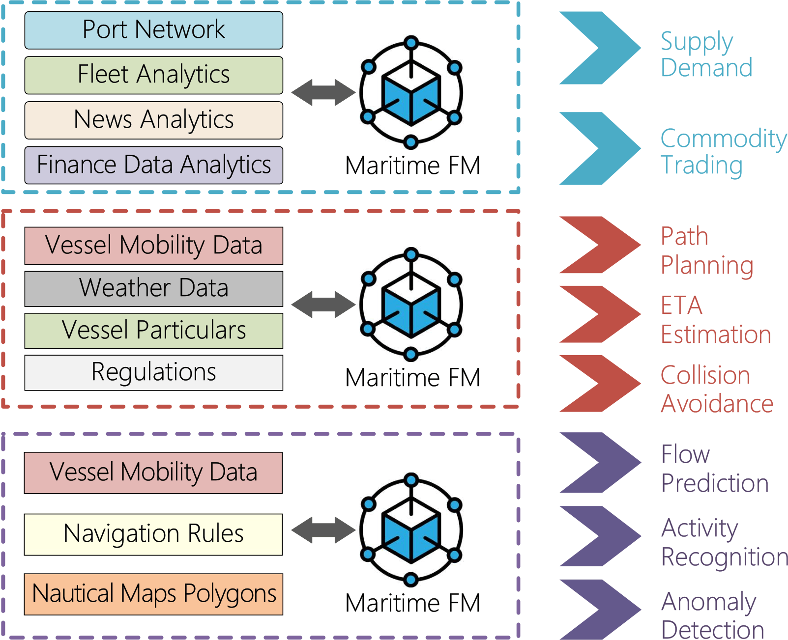
Fleet deployment, contract allocation, multi-port service schedules, port hierarchies, and global supply-demand dynamics.
Route design between ports while accounting for weather, vessel type, dimensions, ice-class constraints, port access rules, and piracy risk.
Speed adjustments, collision avoidance, COLREGs compliance, traffic separation schemes, and reactions to disruptions during a voyage.
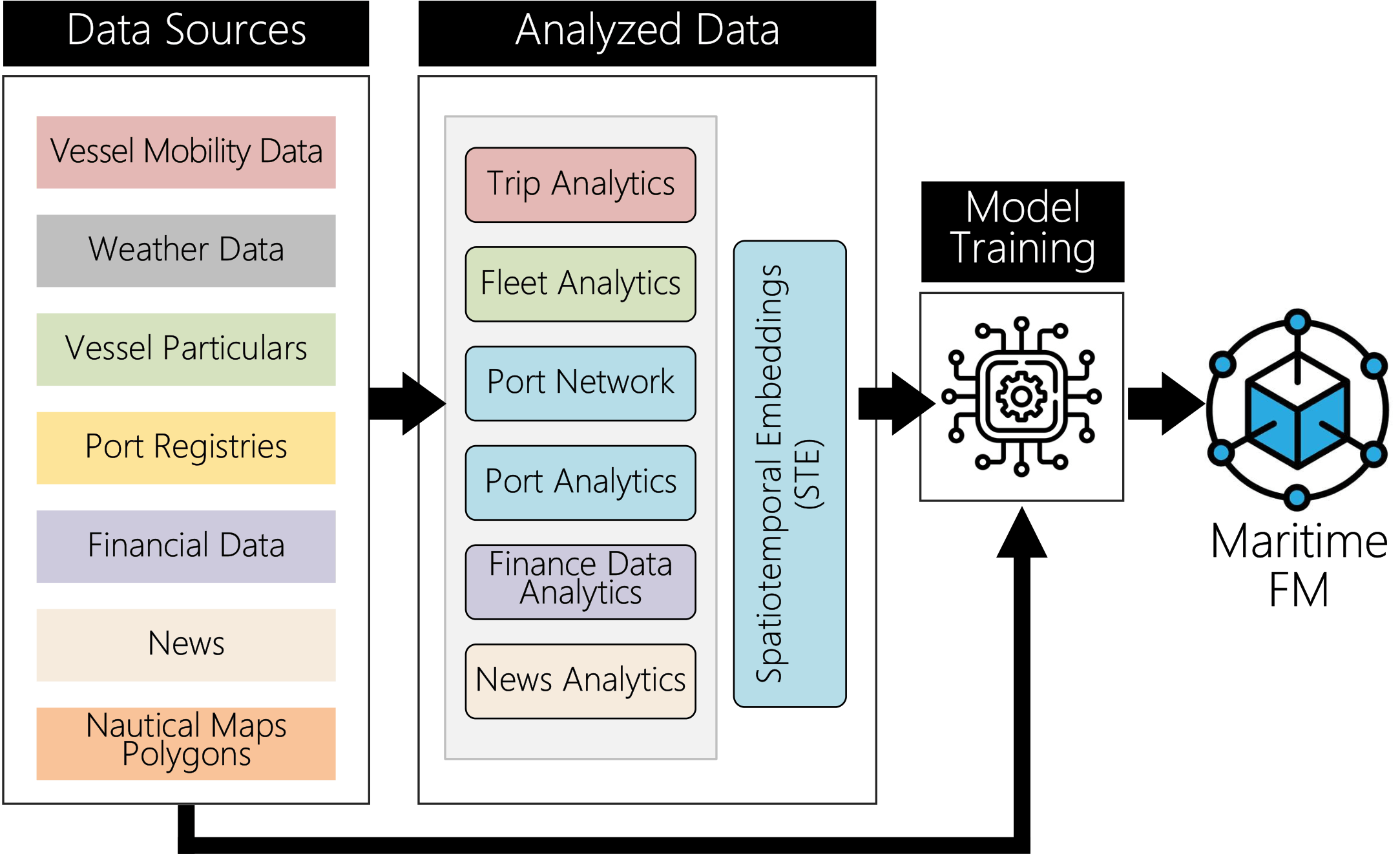
The paper proposes an STE-augmented pipeline: data sources are analyzed, aligned spatially and temporally, embedded, and then used to train a Maritime FM.
Combine AIS mobility data, weather, vessel particulars, port registries, financial data, news, and nautical-map polygons.
Derive trip analytics, fleet analytics, port network statistics, port analytics, finance signals, and news analytics.
Use spatiotemporal embeddings as a first-level fusion mechanism that aligns and selectively retains relevant features.
Pretrain on large-scale maritime history and adapt the backbone to navigation, monitoring, and shipping intelligence tasks.
AIS tracks, speed, heading, destination, movement gaps, and trajectory patterns.
Registry attributes such as type, dimensions, flag, age, ownership, and technical capabilities.
Port metadata, terminals, berths, facilities, access constraints, and regional organization.
Traffic schemes, maritime zones, regulated areas, coastlines, and navigational constraints.
Wind, waves, currents, tides, forecasts, and regional environmental patterns.
Bathymetry, depth grids, coastal constraints, and static environmental context.
Freight benchmarks, commodity prices, financial time series, and sector-level demand signals.
Disruptions, geopolitical developments, safety notices, and market sentiment signals.
These sources differ in modality, update frequency, availability, and quality, so the FM requires robust spatiotemporal alignment and missing-data handling.
AIS coverage gaps, spoofing, fragmented port metadata, coarse weather grids, and asynchronous update cycles can weaken model reliability.
STEs can align trajectory records with environmental, regulatory, operational, and market signals while masking irrelevant or missing features.
Maritime networks shift under crises, congestion, weather, geopolitical disruptions, and changing trade dynamics.
Gradual retraining can keep the FM aligned with evolving maritime behavior without rebuilding the full model from scratch.
Captains, operators, companies, and authorities need recommendations that are understandable, actionable, and compliant with maritime rules.
Explainable maritime FMs can provide reasoning traces, confidence, provenance, and safer interaction with autonomous and remotely operated systems.
Combining public AIS with proprietary market or operational data can expose sensitive commercial strategies.
Approaches such as differential privacy, attribution controls, and regulation-aware inference can support responsible deployment.
The adapted model can support single-vessel and cooperative planning.
Learned routine behavior can support monitoring at vessel and network scale.
Trajectory data combined with market embeddings can support business and network analysis.
The downstream view groups maritime FM use cases by the kind of context they require. Market-facing applications use port, fleet, finance, and news analytics; navigation applications combine vessel mobility, weather, vessel particulars, and regulations; monitoring applications combine mobility data, rules, and nautical-map polygons.
This makes the page easier to scan while preserving the paper's core message: the same multimodal backbone can serve very different maritime decisions.
Landscape of Key Literature Across Core Topics.
@misc{spiliopoulos2026multimodalmaritimefm,
  title  = {Multimodal Maritime Foundation Models: Challenges and Opportunities},
  author = {Spiliopoulos, Giannis and Troupiotis Kapeliaris, Alexandros and Patroumpas, Kostas and Betchavas, Panagiotis and Skoutas, Dimitrios and Zissis, Dimitris and Bikakis, Nikos},
  year   = {2026}
}