Annotate mobility
Detect stops, gaps, speed changes, slow motion, turns, and noisy positions in raw AIS streams.
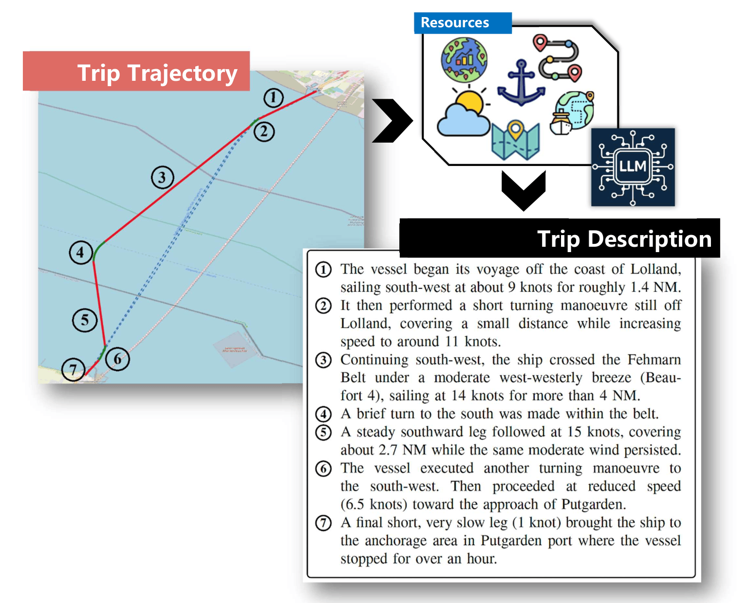
From Vessel Trajectories to Context-enriched LLM-generated Trip Narrative
Archimedes/Athena RC · University of the Aegean · Athena RC · Hellenic Mediterranean University
This paper addresses the gap between raw AIS vessel data and the structured representations needed for human interpretation and machine reasoning. The proposed framework segments noisy trajectories into trips and mobility episodes, then enriches each episode with contextual information from geographic, maritime, and meteorological sources.
The enriched representations are used as controlled inputs to LLMs, which generate natural-language descriptions of vessel trips. The paper studies whether these descriptions remain relevant, faithful, and correct, and shows how semantic trajectories can support maritime analytics, voyage reports, anomaly analysis, and trajectory reasoning.
Detect stops, gaps, speed changes, slow motion, turns, and noisy positions in raw AIS streams.
Split long trajectories into trips and episodes such as sailing, stopped, turning, maneuvering, and communication gap.
Enrich each episode with ports, coastal features, offshore areas, traffic schemes, weather, and bathymetry.
Pass context-enriched JSON to LLMs to produce human-readable trip narratives and summary statistics.
Nearby ports, anchorages, and maritime infrastructure used to describe trip endpoints and stops.
Meteorological conditions that explain speed changes, delays, and trip-level context.
Coastal regions, offshore zones, and geographic context for locating vessel movement.
Maritime routes, separation schemes, and navigation areas that help interpret maneuvers.
Sea-depth information used to enrich trajectories with environmental and spatial constraints.
These external sources are combined with AIS-derived episodes before the LLM generation step, so trip narratives can mention not only movement patterns but also the surrounding maritime, geographic, and meteorological context.
@inproceedings{ptsb2026,
  title  = {Context-Enriched Natural Language Descriptions of Vessel Trajectories},
  author = {Patroumpas, Kostas and Troupiotis-Kapeliaris, Alexandros and Spiliopoulos, Giannis and Betchavas, Panagiotis and Skoutas, Dimitrios and Zissis, Dimitris and Bikakis, Nikos},
  booktitle = {IEEE International Conference on Mobile Data Management (MDM)},
  year   = {2026}
}